Wiki-Solar
The authority on utility-scale solar power
- Continent
- Africa
- - East Africa
- - North Africa
- - Southern Africa
- - West Africa
- Asia - Indian Subcontinent
- Asia - Middle East
- Asia - South East
- Asia - Western
- Australasia & Oceania
- - Australasia
- Europe - North Eastern
- Europe - North Western
- Europe - South Eastern
- Europe - South Western
- Central America
- - Caribbean & offshore
- South America
- - Northern
- - Southern
- Country
- Region
- Australia< Eastern
- Canada< Eastern
- China< Central
- China< Eastern
- China< Northern
- China< North West
- China< Southern
- France< Nouvelle-Aquitaine
- France< Occitanie
- France< PACA
- Germany< Eastern
- Germany< Southern
- India< Central
- India < Northern
- India < Southern
- India < Western
- Japan< Kyushu
- Spain< Andalusia
- UK< East England
- UK < East Midlands
- UK< South East
- UK< South West
- UK< Wales
- US< Deep South
- US< Mid Atlantic
- US< Mid South
- US< New England
- US< Pacific West
- US< SouthWest
- Province
- Provinces & Regions
- Canada> Ontario
- Chile> Antofagasta
- Chile> Atacama
- China> Gansu
- China> Inner Mongolia
- China> Jiangsu
- China> Ningxia
- China> Qinghai
- China> Xinjiang
- Germany> Bavaria
- Germany> Brandenburg
- Germany> Mecklenburg-VP
- Germany> Saxony-Anhalt
- India> Gujarat
- India> Karnataka
- India> Madhya Pradesh
- India> Maharashtra
- India> Rajasthan
- India> Tamil Nadu
- India> Telangana
- UK> Cornwall
- UK> Devon
- UK> Hampshire
- UK> Somerset
- UK> Wiltshire
- UK> West Wales & Valleys
- US> Arizona
- US> California
- US> Florida
- US> Massachusetts
- US> New Jersey
- US> North Carolina
- US> Texas
- Solar Parks
- Benban Solar Park, Egypt
- Bhadla Solar Park, IN
- Charanka Solar Park
- Delingha Solar Park
- Golmud Solar Park
- Jinchuan, Gansu
- Jinta, Gansu
- Kurnool Ultra Mega S.P, IN
- Ma'an Solar Park, Jordan
- N P Kunta Solar Park, IN
- Neuhardenberg
- Pavagada Solar Park, IN
- Qili Photoelectricity Park
- Quaid-e-Azam, Pakistan
- Rawra Solar Park, IN
- Rewa Ultra Mega, IN
- Shichengzi PV Park, Kumul
- SMBRAM, Dubai, UAE
- Tengger Solar Park, Zhongwei
- University of Arizona Science and Technology Park
- Wuwei Fengle, Gansu
- Footprints
- More
@WikiSolar | Standard | Copyright © WolfeWare Ltd |
Site area, site plans and satellite views
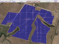
Our site footprints give more precise data (where available) about the area covered by each solar power plant. For established projects this is obtained from satellite imagery. Otherwise, and for projects in development, it may come from site plans, photographs or planning submissions.
Selected solar clusters & plants
In the pull-down menu above, names starting with < are clusters of multiple solar power plants sited in the same locatilty, as further described here. Names indicated by > are individual solar power plants.
What area do we include?
Ground-mounted free field sites: In general, the site area shown is all that is enclosed within any perimeter fencing for the project. Unfenced projects show the area of the solar arrays plus a surrounding border, to allow for the area are likely to be required for maintenance access. Widely dispersed sites - such as hiltop arrays - may show an irregular perimeter to enclose the area visibly covered by solar arrays.
Because we typically show the entire fenced area, some projects may have a larger footprint than is strictly necessary for the solar generating station; for example if fencing is taken around ponds or woodland within the project area.
For simplicity, wavy or crooked boundary lines may be shown as straight lines on our maps. To avoid complexity in some cases where roads, paths, streams, power lines and other features cross solar sites, these may be included in the indicated site area, even when they are fenced separately.
Where plants are directly connected to separately fenced transmission stations, these are normally excluded from the indicated area because such substations are often under the management of the network operator rather then the solar plant.
Other sites: Rooftop projects typically indicate the outline of the roofs on which they solar arrays are mounted, unless the array visibly covers substantially less then the total area. Neighbouring buildings, if included, may be shown within a single boundary.
Car-port projects typically show that part of the car park that is largely covered by solar canopies.
Floating projects show roughy the area of the surface of the reservoir or body of water, if largely covered by the floating array. Otherwise the boundary will be an approximation to contain all the floating platforms.
Satellite images
All of the maps in this website are displayed using cartography and satellite images from Google Maps.
Google regularly updates its satellite images, but the frequency with which this happens varies in different parts of the world. There may be some instances where solar generation stations have been in existence for several years but still do not appear on the satellite images.
Which projects do we show?
Wiki-Solar's aim is to show site footprints of all projects on our Database for which they are available. .
We also show some other plants, such as:
- solar PV projects which are too small to meet our selection criteria
- a few remewable projects of other technologies
where these are geographically close to utility scale solar projects in the Wiki-Solar Database.
Incomplete / no satellite view?
Because Google Maps uses different images at different magnification levels you may sometimes need to zoom in or zoom out to see the solar project on the map.
Some site footprints have been captured from satellite images from providers other than Google. These may not yet appear on Google Maps, but probably will if you return in a few months time.
Some projects may be captured during the construction stage, and you may need to return later to see the completed installation.
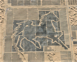
Solar power plants as art
A few solar power plants have been configured to show specific shapes, when viewed from above. See some examples here.

Site plans
The Wiki-Solar maps show site plans for many of the plants
